|
|
Weather Alert |
| Buncombe County, NC | |||||||||
|
|
||||||||
|
Canceled 5/13/25 2:40 AM Flood Advisory issued May 12 at 9:12PM EDT until May 13 at 2:45AM EDT by NWS Greenville-Spartanburg SC * WHAT... Flooding caused by excessive rainfall is expected. * WHERE... Eastern Buncombe County, northeastern Henderson County, and western Rutherford County in North Carolina. * WHEN... Until 245 AM EDT. * IMPACTS... Nuisance flooding of low-lying areas adjacent to streams and other poor-drainage areas, including farmland, parks, greenways, boat-access areas, golf courses, underpasses, and parking lots. Isolated, shallow flows over roadways is possible. A few flood-prone, low-water crossings may become impassible. A small culvert washout or two is possible. * ADDITIONAL DETAILS... - At 850 PM EDT, Periods of light rainfall continue to pivot into the central Blue Ridge Escarpment of North Carolina following several rounds of light to moderate rainfall which began early Monday morning. While short-term rates have not been significant enough to cause flash-flood concerns, the Advisory area has seen 1.5-3 inches since early Monday morning. This rainfall is beginning to produce excessive runoff into the following streams and associated tributaries: (Rocky) Broad River near Gerton, Bat Cave and Chimney Rock; Swannanoa River near Montreat, Black Mountain, and Swannanoa; Clear Creek near Edneyville; and Cane Creek near Fairview. Over the next several hours, stream levels are expected to gradually rise and exceed bankfull levels in several locations. Flood-prone areas along these streams are likely to see developing nuisance flood conditions over the next several hours. Areas of imminent concern include along the Rocky Broad River near Bat Cave, Chimney Rock, and Lake Lure, where rising stream levels are currently approaching bankfull or Action Stage. High flows from the headwaters of the Swannanoa River may cause rising stream levels downstream from Swannanoa to Biltmore Village, but absent additional and prolonged heavy rainfall, levels are expected to stay below bankfull levels. High flows from the headwaters of the Broad River may cause rising stream levels downstream of Lake Lure, resulting in stream levels approaching bankfull conditions. Stay weather aware and heed guidance from local officials as necessary. - Rounds of moderate to heavy showers and a few embedded thunderstorms are possible generally after 10pm as the best instability moves through the Advisory area. Once they begin, these showers and storms may persist for 2-4 hours during the overnight period. Given the saturated soils and increasing stream flows, resultant runoff from this activity may be significant enough to produce flash flooding. Therefore, those in the Advisory area are encouraged to stay weather aware later tonight as a Flash Flood Warning or two may be needed should those heavier rainfall rates materialize. A Flood Watch for flash flooding remains in effect through 8am Tuesday. - Some locations that may experience nuisance to Minor flooding include...Black Mountain, Swannanoa, Fairview, town of Lake Lure, Chimney Rock Village, Bat Cave, Chimney Rock State Park, Montreat, Gerton, Edneyville, Dana, and Shingle Hollow. - Http://www.weather.gov/safety/flood 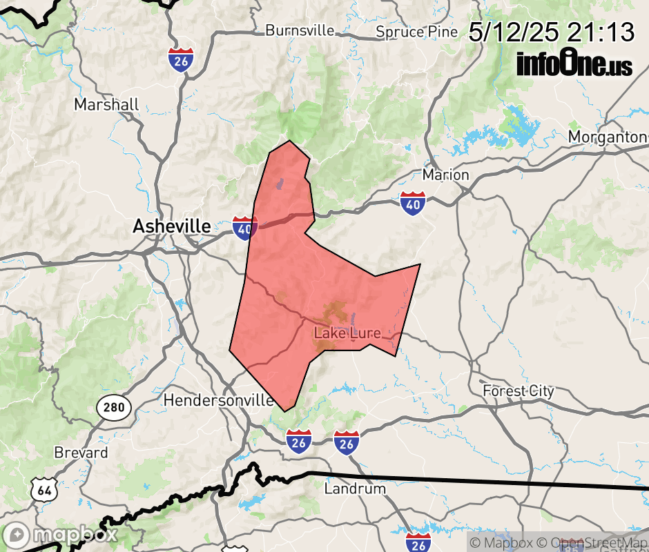 |
|||||||||
 Why aren't you using the InfoOne app? Why aren't you using the InfoOne app?
Stay abreast of information affecting your community! InfoOne tracks real-time information such as:
InfoOne currently supports over 100 communities in NC, VA and WV, and our coverage area is steadily growing. It's free! Install the InfoOne app today and see what you've been missing. |
|||||||||