|
|
Weather Alert |
| Mecklenburg County, NC | |||||||||
|
|
||||||||
|
Canceled 8/5/25 12:39 PM Flash Flood Warning issued August 5 at 11:27AM EDT until August 5 at 4:15PM EDT by NWS Greenville-Spartanburg SC At 1127 AM EDT, Doppler radar and automated gauges indicate moderate rainfall due to numerous rounds of showers moving through the Charlotte metro area. Storm-total rainfall over the past 4-6 hours has exceeding 3-4 inches across much of southern Mecklenburg County. The heaviest rainfall has occurred along Little Sugar Creek, where isolated totals of 4-5" have been observed, including near Starmount Forest and Sedgefield. Flash flooding is ongoing with additional areas of flooding expected to develop, especially downstream of primary streams in the southern Charlotte metro area. Ongoing flooding may worsen over the next 1-2 hours as the heaviest rain begins to depart the metro area. * Areas of greatest concern include: 1) along Little Sugar Creek and feeder drainages from near 36th Street to Medical Center Drive to Hillsdale Ave and Seneca Place. 2) along Steele Creek and feeder drainages near John Price Rd, Arrowood Mobile Home Park, and Carowinds Blvd 3) along Briar Creek and feeder drainages from near Shamrock Dr to Independence Blvd to Colony Rd. * The Flash Flood Warning was reduced in size to capture the areas of greatest concern. Northern Mecklenburg County is not expected to experience significant flash flooding. A Flood Advisory remains in effect there due to continued concerns for isolated nuisance flooding. HAZARD...Life-threatening flash flooding. Heavy rain producing flash flooding. SOURCE...Radar and automated gauges. IMPACT...Life-threatening flash flooding of creeks and streams, urban areas, highways, streets and underpasses. Impacts to structures adjacent to drainages and streams are possible, and residents and businesses are urged to move away from streams. Some locations that may experience flash flooding include... Uptown Charlotte, Central Charlotte, South Charlotte, Southwest Charlotte, East Charlotte, Northeast Charlotte, Northwest Charlotte, Matthews, Mint Hill, Pineville, Marvin, Southpark, Freedom Park, The Arboretum, The Plaza, Hidden Valley, Carowinds, Paw Creek and Steele Creek. The heaviest rainfall is moving through the southern parts of Charlotte, including from Pineville to Matthews, and will depart the area over the next 30-60 minutes from west to east. Expect flooding headwaters to crest and for conditions to gradually improve after noon with the resultant floodwave impacting downstream locations closer to the SC state line over the next 2-5 hours. The Flash Flood Warning will remain in effect until most streams have crested and conditions have significantly improved, with only nuisance flooding remaining. Isolated areas of Moderate flooding, with significant inundation of flood-prone roads and a few structural impacts, are still possible over the next 1-2 hours. Drivers are urged to exercise extreme caution and obey all barricades. Residents and businesses are urged to protect life and move away from streams. 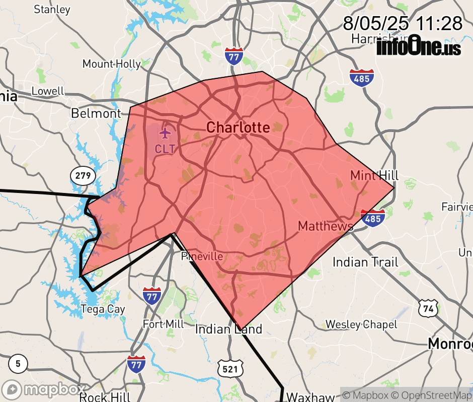 |
|||||||||
 Why aren't you using the InfoOne app? Why aren't you using the InfoOne app?
Stay abreast of information affecting your community! InfoOne tracks real-time information such as:
InfoOne currently supports over 100 communities in NC, VA and WV, and our coverage area is steadily growing. It's free! Install the InfoOne app today and see what you've been missing. |
|||||||||