|
|
Weather Alert |
| Rowan County, NC | |||||||||
|
|
||||||||
|
Canceled 7/9/25 10:23 PM Flood Advisory issued July 9 at 7:49PM EDT until July 9 at 10:45PM EDT by NWS Greenville-Spartanburg SC * WHAT... Nuisance to Minor flooding caused by excessive rainfall is expected. * WHERE... A portion of piedmont North Carolina, including the following counties, Davie, Iredell, and Rowan. * WHEN... Until 1045 PM EDT. * IMPACTS... Nuisance to Minor flooding of low-lying areas adjacent to streams and other poor-drainage areas, including farmland, parks, greenways, boat-access areas, golf courses, underpasses, and parking lots. Isolated, shallow flows over roadways is possible. A few flood-prone, low-water crossings may become impassible. A small culvert washout or two is possible. * ADDITIONAL DETAILS... - At 738 PM EDT, Doppler radar and automated rain gauges indicated heavy rain is ongoing due to multiple slow-moving thunderstorm cells extending southwest to northeast from Troutman and Doolie to Mount Ulla, Cleveland, Woodleaf, Cooleemee, Fork Church, and Advance. Between 1 and 2 inches of rain has fallen over the past 45-60 minutes. These cells are training from southwest to northeast over the same areas, prompting concerns for excessive runoff capable of producing areas of nuisance to Minor flooding. Areas of greatest concern include along the headwaters of North Second Creek from Mount Ulla to Woodleaf, including flood-prone low-water crossings at White Rd, Lyerly Rd, Upright Rd, Graham Rd, Hall Rd, Childers Rd, and Bear Poplar Rd. Additionally, areas along Third Creek and associated tributaries, from eastern portions of Statesville and points east, including near Shiloh Rd, Triplett Rd, Third Creek Church Rd, and Carson Rd. Urbanized areas including eastern Stateville and Cleveland may experience deep ponding due to poor drainage. - An additional 2-3 inches of rain is possible over the next 60-90 minutes due to these very slow-moving cells and the movement of additional thunderstorm cells into the Advisory area from the south and west. This rainfall may exacerbate developing flooding or cause new areas of flooding to develop. If these cells persist for an additional 60 minutes or longer, a Flash Flood Warning may be issued. Caution is advised near any stream or other vulnerable area. Seek higher ground immediately if streams start to rise. Please have a plan in place should flash flooding develop and do not hesitate to act. - Some locations that may experience nuisance to Minor flooding include... Salisbury, Statesville, Mocksville, Mooresville, Troutman, Cooleemee, Cleveland, Lake Norman State Park, Woodleaf, Mount Ulla, Fork Church and Advance. - http://www.weather.gov/safety/flood 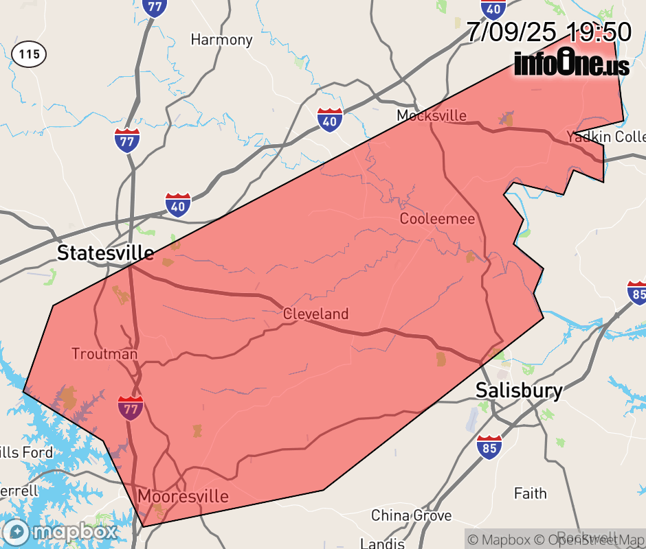 |
|||||||||
 Why aren't you using the InfoOne app? Why aren't you using the InfoOne app?
Stay abreast of information affecting your community! InfoOne tracks real-time information such as:
InfoOne currently supports over 100 communities in NC, VA and WV, and our coverage area is steadily growing. It's free! Install the InfoOne app today and see what you've been missing. |
|||||||||