|
|
Weather Alert |
| Clarke County, VA | |||||||||
|
|
||||||||
|
Canceled 5/14/25 9:40 PM Flood Warning issued May 14 at 10:37AM EDT until May 16 at 10:40AM EDT by NWS Baltimore MD/Washington DC ...The Flood Warning continues for the following rivers in Maryland...West Virginia...Virginia... North Branch Potomac River Near Cumberland affecting Allegany, Mineral and Hampshire Counties. Potomac River at Harpers Ferry affecting Washington and Jefferson Counties. Shenandoah River at Millville affecting Jefferson, Warren and Clarke Counties. Rapidan River Near Culpeper affecting Culpeper, Orange and Spotsylvania Counties. Opequon Creek near Martinsburg affecting Berkeley and Jefferson Counties. Cacapon River near Great Cacapon affecting Morgan County. Rappahannock River at Fredericksburg affecting Spotsylvania, City of Fredericksburg and Stafford independent cities. ...The Flood Warning is extended for the following rivers in West Virginia...Maryland...Virginia... South Branch Potomac River near Springfield affecting Hardy and Hampshire Counties. Potomac River at Paw Paw affecting Morgan, Allegany and Hampshire Counties. Potomac River at Shepherdstown affecting Berkeley, Washington and Jefferson Counties. Potomac River at Point of Rocks affecting Loudoun and Frederick Counties. Potomac River at Edwards Ferry affecting Montgomery and Loudoun Counties. Rappahannock River at Remington affecting Culpeper and Fauquier Counties. Conococheague Creek at Fairview affecting Washington County. For the South Branch Potomac River...including Franklin, Moorefield - SF, Petersburg, Springfield...Minor flooding is forecast. For the Potomac River...including Paw Paw, Hancock, Shepherdstown, Harpers Ferry, Point of Rocks, Edwards Ferry, Little Falls... Moderate flooding is forecast. For the Shenandoah River...including Millville...Minor flooding is forecast. For the Rappahannock River...including Remington, Fredericksburg, Fredericksburg...Minor flooding is forecast. For the Rapidan River...including Culpeper...Minor flooding is forecast. For the Conococheague Creek...including Fairview...Minor flooding is forecast. For the Opequon Creek...including Martinsburg...Minor flooding is forecast. For the Cacapon River...including Great Cacapon...Minor flooding is forecast. * WHAT... Minor flooding is forecast. * WHERE... Shenandoah River at Millville. * WHEN... From this afternoon to late Friday morning. * IMPACTS... At 12.0 feet, Water reaches the river access at Wagon Trail Place near Harpers Ferry, and completely covers the parking lot of the lower boat ramp at Millville Dam. Portions of the Cool Spring Battlefield begin to flood. * ADDITIONAL DETAILS... - At 9:30 AM EDT Wednesday the stage was 6.0 feet, or 4.0 feet below flood stage. - Forecast...The river is expected to rise above flood stage late this afternoon to a crest of 12.5 feet just after midnight tonight. It will then fall below flood stage early Friday morning. - Flood stage is 10.0 feet. - Flood History...This crest compares to a previous crest of 12.5 feet on 01/02/1976. - Please visit www.weather.gov/safety/flood for flood safety and preparedness information 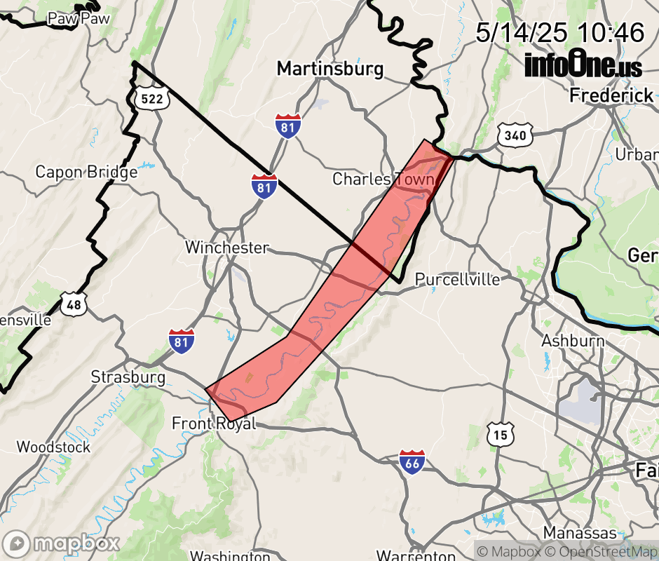 |
|||||||||
 Why aren't you using the InfoOne app? Why aren't you using the InfoOne app?
Stay abreast of information affecting your community! InfoOne tracks real-time information such as:
InfoOne currently supports over 100 communities in NC, VA and WV, and our coverage area is steadily growing. It's free! Install the InfoOne app today and see what you've been missing. |
|||||||||