|
|
Weather Alert |
| McDowell County, NC | |||||||||
|
|
||||||||
|
Canceled 5/13/25 2:42 AM Flood Advisory issued May 12 at 8:38PM EDT until May 13 at 8:15AM EDT by NWS Greenville-Spartanburg SC * WHAT... Nuisance to Minor flooding caused by excessive rainfall is expected. * WHERE... Central and western McDowell County, North Carolina * WHEN...Until 815 AM EDT Tuesday. * IMPACTS... Nuisance flooding of low-lying areas adjacent to streams and other poor-drainage areas, including farmland, parks, greenways, boat-access areas, golf courses, underpasses, and parking lots. Isolated, shallow flows over roadways is possible. A few flood-prone, low-water crossings may become impassible. A small culvert washout or two is possible. * ADDITIONAL DETAILS... - At 823 PM EDT, Rounds of light to moderate rainfall continue to pivot into McDowell County, impacting the upper Catawba River and associated tributaries, including the North Fork Catawba River, Mill Creek, Crooked Creek, Curtis Creek, Mackey Creek, Buck Creek, Nix Creek, and Toms Creek. While short-term rates have not been significant enough to cause flash-flood concerns, the Advisory area has seen 1.5-3 inches since early Monday morning. This rainfall is beginning to produce excessive runoff into the above streams and associated tributaries. Over the next several hours, stream levels are expected to gradually rise and exceed bankfull levels in several locations. Flood-prone areas along these streams from Old Fort to Lackeytown to Greenlee, Sunnyvale, Pleasant Gardens, Marion, and Woodlawn are likely to see developing nuisance flood conditions over the next several hours. As these high flows move into the upper Catawba River into the nighttime hours, expect the upper Catawba River to approach and possibly exceed bankfull levels later tonight. - Rounds of moderate to heavy showers and a few embedded thunderstorms are possible generally after 10pm as the best instability moves through the Advisory area. These showers and storms may persist for several hours into the overnight. Given the saturated soils and increasing stream flows, resultant runoff from this activity my be significant enough to produce flash flooding. Therefore, those in the Advisory area are encouraged to stay weather aware later tonight as a Flash Flood Warning or two may be needed should those heavier rainfall rates materialize. A Flood Watch for flash flooding remains in effect through 8am Tuesday. - Some locations that may experience nuisance to Minor flooding include... Marion, Old Fort, Lake James State Park, Pleasant Gardens, Sugar Hill, Woodlawn, Little Switzerland, and Nebo. - Http://www.weather.gov/safety/flood 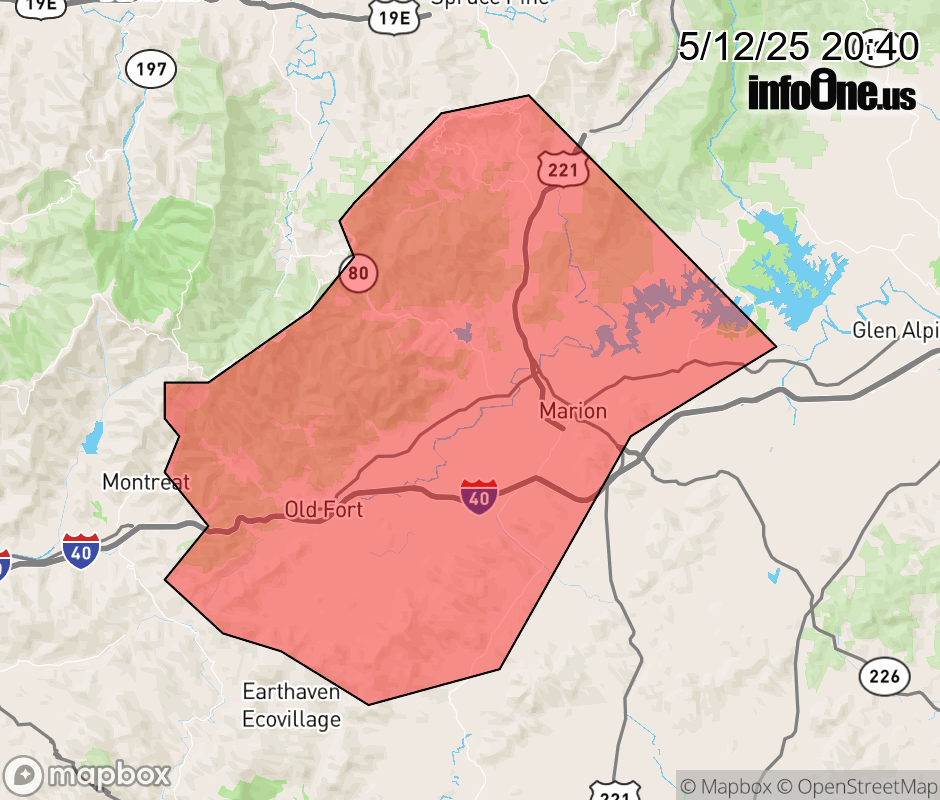 |
|||||||||
 Why aren't you using the InfoOne app? Why aren't you using the InfoOne app?
Stay abreast of information affecting your community! InfoOne tracks real-time information such as:
InfoOne currently supports over 100 communities in NC, VA and WV, and our coverage area is steadily growing. It's free! Install the InfoOne app today and see what you've been missing. |
|||||||||