|
Weather Alert |
| Gaston County, NC | |||||||||
|
|
||||||||
|
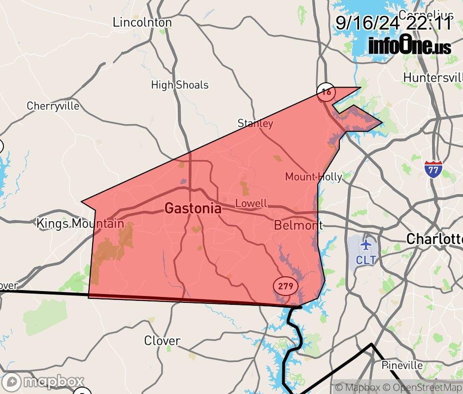
Canceled 9/17/24 1:20 AM Flood Advisory issued September 16 at 10:08PM EDT until September 17 at 4:00AM EDT by NWS Greenville-Spartanburg SC * WHAT... Flooding caused by excessive rainfall is expected. * WHERE... Central, southern, and eastern Gaston County, North Carolina * WHEN...Until 400 AM EDT Tuesday. * IMPACTS... Nuisance flooding of low-lying areas adjacent to streams and other poor-drainage areas, including farmland, parks, greenways, boat-access areas, golf courses, underpasses, and parking lots. Isolated, shallow flows over roadways is possible. A few flood-prone, low-water crossings may become impassible. A small culvert washout or two is possible. * ADDITIONAL DETAILS... - At 958 PM EDT, Doppler radar and automated rain and streamgauges indicate that portions of Gaston County, primarily along a line from Bessemer City to Dallas, Stanley and Mount Holly, have seen between 2 and 3 inches of rainfall over the past 4-6 hours as a result of the outer rainbands of a weak coastal low pressure system. Over the past two hours, more intense bands have been pivoting over southern and eastern Gaston County, including over the city of Gastonia, capable of producing rainfall rates of 1-1.5 inches per hour. These bands are pushing west toward Bessemer City and Kings Mountain with lighter rainfall entering Gaston County from the east. Nevertheless, these bands have enhanced areas of excessive runoff and are increasing the rate of rise along area streams. Several headwaters will be reaching and exceeding bankfull conditions within the next 15-60 minutes, resulting in nuisance flooding of adjacent low-lying areas. Areas of greatest concern include from Crowders to Gastonia to Belmont, Cramerton, and Mount Holly within flood-prone areas adjacent to streams and other common, flood-prone poor- drainage areas, roadways, and intersections. The streamgauge along Catawba Creek at E Hudson Blvd indicates bankfull conditions are imminent and flooding of the Catawba Creek Greenway and adjacent low-lying, flood-prone areas will occur within the next 15-30 minutes. Floodwaters may reach 1-3 feet deep along the greenway and within the floodplain as the stream rises to near 10 feet over the next 1-2 hours. - Soils are saturated and streams are swollen. Therefore, additional heavy rain may quickly create new areas of flooding and cause previous areas of flooding to redevelop. As a result, a Flash Flood Warning may be issued later tonight if conditions continue to deteriorate. Caution is advised near any stream or other vulnerable area. Seek higher ground immediately if heavy rain develops and streams rise quickly. Please have a plan in place should flash flooding develop and do not hesitate to act. - Some locations that may experience nuisance flooding include... Gastonia, Huntersville, Kings Mountain, Mt Holly, Belmont, Bessemer City, South Gastonia, Dallas, Stanley, Cramerton, Lowell, Ranlo, Mcadenville, Crowders Mountain State Park, Kings Mountain State Park, Crowders and Lucia. - Http://www.weather.gov/safety/flood  |
|||||||||
 Why aren't you using the InfoOne app? Why aren't you using the InfoOne app?
Stay abreast of information affecting your community! InfoOne tracks real-time information such as:
InfoOne currently supports over 100 communities in NC, VA and WV, and our coverage area is steadily growing. It's free! Install the InfoOne app today and see what you've been missing. |
|||||||||